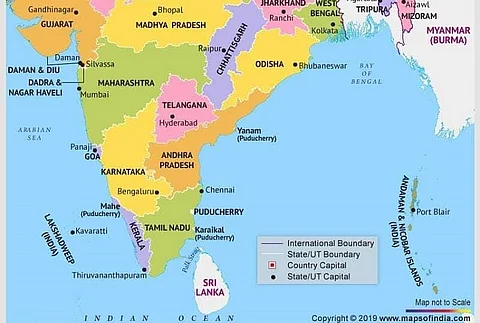

A latest map of India released by the Centre after the abrogation of Article 370 has triggered a row, as Amaravati, the capital of Andhra Pradesh was missing from it.
The new map was issued after reorganisation of the new union territories of Jammu & Kashmir and Ladakh, which was officially done on October 31.
The map showed the outlines of all states, with the capitals marked in red. While the state of Telangana saw Hyderabad being marked clearly, many were upset as Amaravati did not find a place.
Maps of newly formed Union Territories of #JammuKashmir and #Ladakh, with the map of #India
— PIB India (@PIB_India) November 2, 2019
Details: https://t.co/Hf1Mn9iZDo pic.twitter.com/3fIeXR59rK
Andhra Pradesh was bifurcated in 2014 and Telangana was carved out of it. While it was initially decided that Hyderabad would serve as the common administrative capital for a period of 10 years, former AP Chief Minister Chandrababu Naidu soon announced the state's capital as Amaravati, by the banks of river Krishna.
Users pointed out that Prime Minister Narendra Modi had himself attended the ground breaking ceremony of the capital city, and a temporary Secretariat, Assembly and High Court had been built. However, the current YSRCP government has said that the previous TDP government failed to notify Amaravati as capital.
Though the capital was not notified in the gazette, in December 2014, the Andhra Pradesh Capital Region Development Authority Act was notified in the gazette. Accordingly, seed roads connecting various villages under the capital region have also been constructed along with quarters for various government employees. A Capital Region Development Authority (CRDA) is presently functional. A bureacrat who worked closely with the TDP government said that the state had not notified the Home Ministry about the new capital and therefore the map would have omitted the name.
Capital of AP is NOT shown in both the maps
— Sridhar Lanka (@sridhar16507109) November 3, 2019
Andhra Pradesh doesn't have a capital ? @ysjagan https://t.co/HIs2U8Sk99
— Nayab Vakeel (@vidushakvakeel) November 2, 2019
Where is the capital of #AndhraPradesh https://t.co/71z8ePjK34
— Naveena Ghanate (@TheNaveena) November 2, 2019
TDP government categorically said Amaravati is new capital. PM came for ground breaking ceremony. Secretariat, assembly, high court were built. Seed capital roads and officers quarters were almost done. CRDA (capital region development authority) was setup and still in force.
— anigalla (@anigalla) October 31, 2019
The controversy comes at a time when an expert panel constituted by Andhra Pradesh government has sought people's opinion on state capital Amaravati and other projects, to decide its future. While the TDP was keen on developing Amaravati as a modern megalopolis, the YSRCP has not been too eager on the prospect. The YSRCP has also alleged that there was large scale corruption in handing out contracts for Amaravati and many investigations have been ordered after Jagan Mohan Reddy was sworn into power.
Meanwhile, the five-member committee, comprising urban planning experts, is headed by retired IAS officer G. Nageswara Rao, and will receive opinions and suggestions from people until November 12. The committee can be contacted at expertcommittee2019@ gmail.com or via post, at No. 56-15-53, Vinayaka Temple Rd, Patamata, Vijayawada, 520010.
Municipal Administration Minister Botsa Satyanarayana had said that the government will decide on the development of Amaravati after the expert committee's report.
Releasing the new map of India, the Centre said that the new Union Territory of Ladakh consists of two districts -- Kargil and Leh. The rest of the former state of Jammu and Kashmir is in the new Union Territory of Jammu and Kashmir.