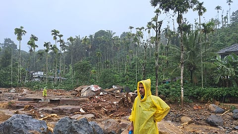
The heavy rains that battered Wayanad were the immediate trigger for the massive landslide in Vellarimala that killed around 270 persons, left more than 200 missing, injured many, and displaced hundreds of families. The Puthumala gauge (which covers Vellarimala area too) of the Hume Centre for Ecology and Wildlife Biology in Kalpetta recorded 572 mm of rain in 48 hours before the landslide. In a location like Vellarimala, experts say that rainfall close to 600 mm is bound to trigger landslides.
TNM spoke to Dr Abhilash S, the director of the Advanced Centre for Atmospheric Radar Research in CUSAT, Ernakulam. He explained the changes in cloud formations above the Wayanad region in the past decade and the resultant increase in mini cloudbursts that could potentially lead to landslides like the one in Vellarimala.
Abhilash explained that the proximity of Vellarimala to Puthumala, where a landslide hit in 2019, points to the fact that the Meppadi panchayat, where the two landslide points are located, is a hazardous area susceptible to landslides. “Almost 50% of western Wayanad is susceptible to landslides. Of this, Meppadi is an especially vulnerable region,” he had earlier told the media.
Studies conducted by the Centre in CUSAT and other institutions in the wake of the 2019 landslides have shown that the formation of deep cumulonimbus clouds has increased in the southeast Arabian Sea off the Kerala coast, leading to a higher occurrence of mini cloud bursts. A cloud burst is an excessive amount of rainfall within a short span of time.
“The geological conditions of Meppadi, combined with the excessive rain are the cause of the landslide,” he said.
Speaking to TNM, Abhilash observed, “The rains received over the last two weeks could have increased the pore water pressure (pressure of groundwater held within a soil or rock, in gaps between particles).” This, aggravated by the excessive rainfall in the two days before the incident, led to the landslide.
On many of the landslides in the recent past occurring at night, Abhilash said the pattern of rains in the recent past in Kerala, showed that intense rainfall is received either early in the morning or late in the evening.
As geologist Dr K Soman explained to TNM, the steep topography of the affected areas was also an aggravating factor. The drop of almost 1,000 metres from Vellarimala to Mundakkai and Chooralmala meant that the debris flow was extremely heavy. “Steepness of the slope leads to higher pull velocity,” Abhilash said, explaining the large-scale devastation caused on the path of the landslide.
Even as rescue efforts are underway, debates about whether Mundakkai and Chooralmala were landslide-susceptible are also rife. Abhilash explained, “The landslide may have originated in virgin forest land. But Mundakkai and Chooralmala occupy an important drainage basin of Chaliyar, putting them directly on the path of the debris flow. Construction along the river could have even altered its course.”
He further said, “The entirety of Western Ghats is around 30 million years old. Every geological event or change is important and must be accounted for when developing human habitation on these mountains.”
