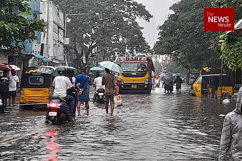

Nearly all global forecast models missed predicting the extremely high rainfall that Chennai witnessed on Thursday, December 30. Over a span of six to seven hours on Thursday, areas like Mylapore and MRC Nagar received 20 centimetres (200 mm) of rain. It was close to the 23 cm of rainfall that Chennai recorded over 24 hours on November 6-7 this year, the highest rainfall since 2015. This seems to have puzzled even the most reliable weather bloggers in Chennai.
What caused the sudden unprecedented rainfall in Chennai? Why was it tough to predict the rains, as weather experts say? TNM spoke to the India Meteorological Department (IMD) and two weather bloggers in Chennai to find answers to some of these questions. But at the centre of the issue is the easterly wave, which, the experts say, made it difficult to predict the sudden, heavy rainfall on Thursday.
According to S Balachandran, Deputy Director of Meteorology, Regional Meteorological Centre, Chennai, the rains on Thursday was not a cyclonic depression. “The sudden rains were due to moisture-laden easterly wave blowing from the lower part of the atmosphere, coupled with strong Westerly troughs. They interacted and caused a sudden, strong bout of rainfall,” Balachandran explains.
Easterly wave, which is a wavelike disturbance of low atmospheric pressure, is common during the Northeast monsoon in Tamil Nadu and occurs in January. Sometimes, they can also bring rainfall — even upto 50 mm or at times 100 mm of rain. However, it is not as easy to predict rainfall levels and location of rainfall in advance with these conditions, said the IMD.
On Thursday morning, the official says, the IMD predicted moderate rains in and around Chennai and neighbouring districts. However, as the intensity of the rainfall started picking up, the IMD began monitoring the weather conditions, including nowcasting (short-term weather prediction, usually for a period of six hours).
“A cyclonic depression will see continuous convergence lines and thus rain. Then a high- and low-pressure system will form, which are synoptic-scale systems. But with the easterly wave, although we receive showers, it is difficult to forecast the intensity of rains well in advance,” Balachandran says.
Weather blogger K Srikanth adds that weather forecasters tend to be conservative when it comes to predicting rains that the easterly wave brings.
“With a cyclonic storm, we predict weather conditions (rainfall etc) on the higher scale. We forecast aggressively. But with the easterly wave, we tend to be more conservative. Because, sometimes, if we predict 50 mm of rainfall, we will likely receive only 5-10 mm of rains,” Srikanth says. Nine out of 10 times, there might be no rain; so it is difficult to pick the right rainfall event and also the impact location.
“On Thursday morning, I predicted rainfall in Pondicherry and delta region. But it ended up raining heavily in Chennai,” Srikanth explains.
The rainfall pattern, too, is different with the easterlies, adds Pradeep John, popularly known as Tamil Nadu Weatherman.
“Generally, the easterly wave gives 15-20 minutes of rainfall, probably 30 mm or so. The clouds will converge and it will rain and then fizzle. Then there will be a break for a few hours and it will drizzle again. This is unlike the cyclonic rains, which is continuous. But on Thursday, we saw continuous rains and thunderstorms, which is not usually observed with the easterlies,”the Tamil Nadu Weatherman tells TNM.
“On Thursday, the clouds were very slow-moving. They did not dissipate and this resulted in all the moisture being dumped on the land,” Pradeep adds.
On his Twitter and Facebook accounts, which he uses to share his analysis of the weather events, Pradeep states a probable reason for the rains on December 30.
“The easterly winds likely got trapped in the region as there was a mid-level ridge. In meteorology, a ridge is an elongated area of relatively high pressure. The ridge had developed 5 km from the surface and we can see that the easterly winds got trapped over Chennai,” Pradeep adds.
Chennai to Delta will be in hot spot for good rains today and tomorrow. What happened yesterday was a freak event and chances of that repeating are less. From Jan 2nd noon rains will reduce drastically or stop
— Pradeep John (Tamil Nadu Weatherman) (@praddy06) December 31, 2021
Reasoning for yesterday rains,rainfall data-https://t.co/eR9uOnAkKm pic.twitter.com/os57ky0RL4
The IMD has predicted heavy to very heavy rain in one or two places over the next couple of days. Sky conditions are likely to be cloudy and maximum and minimum temperatures are likely to be around 30 and 21 degrees Celsius respectively.